THE AFFECTED ENVIRONMENT

THE AFFECTED ENVIRONMENT
AN OVERVIEW OF THE SITE 129
Structures, Facilities, and Grounds 129
Roadways 130
Other Site Elements 131
A Summary of Significant Plans and Projects at President's Park 132
CULTURAL AND NATURAL RESOURCES 135
Cultural Resources 135
Natural Resources 141
Site Capacity 151
HOME and OFFICE OF THE PRESIDENT 153
Executive Residence 153
Executive Office Support Services 154
News Media Facilities 157
VISITOR USE, SERVICES, AND EXPERIENCE 160
Public Access to the White House 160
Who Visits the White House and President's Park? 162
The Visitor Experience 163
Noise 167
SPECIAL EVENTS AND DEMONSTRATIONS 169
Regulations 169
Special Events 171
TRANSPORTATION 175
Local Street Network 175
Site Access 181
Public Parking 182
Public Transit 184
Tourmobile and Tour Bus Circulation 184
Pedestrians 186
Bicycles 187
SOCIOECONOMIC ENVIRONMENT 190
Trends and Forecasts 190
Socioeconomic Characteristics 191
D.C. Revenues 192
Land Use 193
SITE MANAGEMENT AND OPERATIONS 196
Jurisdiction and Security 196
Maintenance Operations 197
Utilities 198

--128--

AN OVERVIEW OF THE SITE

The White House and President's Park consist of an 82-acre parcel north of the Potomac River in Washington, D.C. General boundaries run from H Street at the northern edge of Lafayette Park, east and west to Jackson and Madison Places, south to Pennsylvania Avenue, east and west to 15th and 17th streets, and south to Constitution Avenue. President's Park is adjacent to the Washington Monument, the Tidal Basin, and various other elements that make up the area known today as the Monumental Core

The site consists of a series of general park elements: Lafayette Park on the north; the White House complex, including the Old Executive Office the White House, and the Treasury Building; East Executive Park and West Executive Avenue; and President's Park South, including Sherman Park, First Division Monument, and the Ellipse.

President's Park and the surrounding lands have changed substantially since 1791. L'Enfant's original concept (later reinterpreted by Andrew Ellicott), Andrew Jackson Downing's 1851 plan, and the work of Olmsted brothers in 1935 represent the major specific plans for the property that have generally guided development over the last 200 years. Other general plans, including the 1901 plan by the Senate Park Commission (known as the McMillan plan), also have had some effect, particularly on surrounding traffic patterns, but for the most part they have continued L'Enfant's original vision. Individual projects occurring outside formal planning efforts have at times compromised that original concept; however, great care has usually been taken to preserve the context of the original idea - with President's Park as an important element in the design of the federal capital.

President's Park exists in a neighborhood containing five historic districts and over 60 sites listed as national historic landmarks or on the National Register of Historic Places. In addition, there are 41 commemorative trees and 40 monuments and memorials. The buildings within President's Park range widely in style from Georgian, to Classical Revival and Second Empire, to modernist and post-modernist. The site is also rich in historic archeological resources and has the potential to yield prehistoric resources as well The White House museum collections compare favorably with those of international galleries.

Structures, Facilities, and Grounds

The White House Complex

Areas of the White House complex that are addressed in this document include the Executive Residence, the East and West Wings, East Executive Park, West Executive Avenue, the Old Executive Office Building (OEOB), and the Treasury Building. Various other secondary buildings and facilities within the White House grounds and office areas include maintenance structures, security installations (including a White House visitor entrance building), and various recreational facilities (including a swimming pool, tennis court, basketball hoop, putting green, and running track).

Recreational areas and private garden areas are well-screened from public view by formal and informal planting patterns. Private garden areas include the Rose Garden adjacent to the west colonnade, the Jacqueline Kennedy Garden adjacent to the east colonnade, and the Children's Garden. There are also some yard ornaments, such as an antique marble milk trough. There are 41 commemorative trees

-129-

The Affected Environment

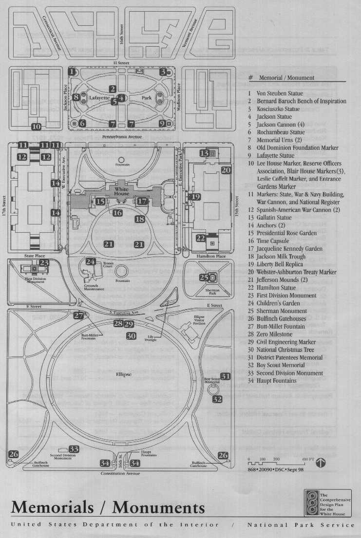
planted by various presidents and first ladies on the White House grounds, plus a boxwood hedge planted by Truman. Other memorials include a 1992 time capsule commemorating the bicentennial of the laying of the White House cornerstone, the handprints of various presidential grandchildren in the Children's Garden, as well as fountains and sculptures.

Lafayette Park

After various earlier designs, Lafayette Park was redesigned by Andrew Jackson Downing in 1851. His plan was reinterpreted by the Corps of Engineers in the 1870s and 1880s and then by the National Park Service in the 1930s. The park was redesigned from 1962 to 1970 by the architectural firm John Carl Warnecke Associates, in association with Mrs. Paul Mellon and the National Park Service. Warnecke's work recast Lafayette Park as the central focus for a national historic preservation initiative in the 1960s Warnecke used Andrew Jackson Downing's earlier design as a framework by which to design an urban park space that would link new construction on the east and west ends of the park while providing for the preservation of significant 19th century streetscapes on Madison and Jackson Places. A lodge built about 1913 in the northeast end of Lafayette Park is now used for maintenance storage; the National Park Service closed the lodge's restroom facility in October 1997 in response to a U.S. Public Health inspection.

Ellipse

The Ellipse was originally a low-lying area and landfill. After a design by Downing, it was brought up to its present grade by 1880, when the circular drive was established. The walk-ways on the Ellipse tend to be informal, except for the circular drive, and they generally follow the routes of pedestrian dirt paths that have evolved over time. A visitor pavilion on the northeast quadrant of the Ellipse (built in 1994) provides visitor services and restrooms.

Two gatehouses designed by architect Charles Bulfinch cat 1827 and originally built for the United States Capitol mark the southeast and southwest corners of the property on Constitution Avenue; they were relocated to these sites in 1880.

Roadways

Roadways in and near President's Park date from various planning efforts. The perimeter streets-H. Jackson, Madison, 15th, and 17th-are all part of L'Enfant's 1791 city plan, while Constitution Avenue was established in the 1870s as B Street over what had originally been the Washington Canal, a waterway that replaced Tiber or Goose Creek in the 1830s.

The date that Pennsylvania Avenue was cut through in front of the White House, separating Lafayette Park from the Executive Residence, is uncertain; it may have been as early as 1796 or as late as cat 1820. East Executive Avenue was established in 1869 and closed to vehicular traffic in 1981. West Executive Avenue was established in 1871 and closed in 1945.

The general design of the north drive on the White House grounds dates from the Jackson administration (1829-37). The drive to the West Wing on the north is a result of the 1902 renovation under McKim, Meade and White; the drive follows the general route of an earlier access road to the greenhouses and other outbuildings. The present circular drive on the south lawn of the White House dates from the 1935 Olmsted plan and replaced an earlier fiddle-shaped drive.

Hamilton and State Places were initially established in conjunction with the Treasury

- 130-

expansion of the 1850s and with the construction of what is now known as the Old Executive Office Building in the 1880s. Portions of E Street were established soon after the turn of the century and expanded between 1933 and 1940 on the recommendations of the Olmsted brothers and other professionals. E Streets present status as a main arterial stems from traffic studies in the 1930s and continuing into the 1960s, which resulted in the combining of E Street and State Place into a major roadway system bisecting the site.

The circular roadway on the Ellipse (dating from the 1880s) is based on Andrew Jackson Downing's 1851 plan. Four secondary curved roadways on the corner of the Ellipse were also established during the 1880s; the north-west roadway was eliminated in the 1930s when E Street and State Place were incorporated into the municipal traffic system.

Other Site Elements

Fencing, coping, sidewalks, benches, trash receptacles, street lighting, and similar items in President's Park date from cat 1948 to the present The 1819 White House gates (forged by Paulus Hedl) were replaced in 1976 with reproductions based on the original design. The gate piers at the north entrances were

-131-

THE AFFECTED ENVIRONMENT

originally erected in 1819-21 and moved 50' to the east and west in 1833. Later piers were designed to match the original north elements. The boulevard lamps the north piers were in place by 1858.

The various monuments and similar installations in President's Park were established between 1853 and 1991. Many are illustrative of the City Beautiful movement of the late 19th and early 20th centuries. They consist of statuary, monuments, and memorial plantings.

A Summary of Significant Plans and Projects at President's Park

Major plans that have affected the development of President's Park from 1791 to present are summarized below. See appendix B for a more complete description.

Pierre Charles L'Enfant, 1791

L'Enfant's 1791 plan for the federal city (revised by Andrew Ellicott and others in 1792) is still obvious in today's city. The city was planned to rest on a series of terraces and to be oriented toward the river. Most important to L'Enfant's vision was a decentralized city, with specific locations identified for the executive, legislative, and judicial branches of government. Broad avenues would radiate from park and plaza areas, providing impressive urban and ceremonial vistas. Overlaid on this radial pattern of avenues would be a street grid system. The Mall and what would become President's Park would form a large L-shaped sward, with the axis point at the mouth of Tiber (Goose) Creek on the Potomac River. L'Enfant envisioned a palace, surrounded by stately grounds, and offices for the executive facing the river and connected to the Capitol by a broad ceremonial avenue later known as Pennsylvania Avenue. President's Park and its uninterrupted vista across the Washington

Monument to the Jefferson Memorial serve as the northern arm of the Mall axis and constitute one of the major elements of L'Enfant's plan.

Thomas Jefferson, ca 1804

Thomas Jefferson's specific plans for the White House and the adjacent grounds remain uncertain. However, it is clear that he felt L'Enfant's park to be too extensive for the president of a republic. He attempted to reduce the substantial acreage of the house site in a number of ways. He envisioned the future Lafayette Park known then as the President's Square) as a public space more oriented to the city and its citizens than to the president. He called for a stone wall to be built around the immediate house grounds in an attempt to scale the property to the house and to separate this area from the executive office buildings to the east and west. Jefferson added east and west service additions to the house as colonnaded Palladian arcades. A vault was built for the treasury to the southeast of the house.

Some of Jefferson's schematics for the landscape survive. Drives from Pennsylvania Avenue into President's Park on the south were designed as romantic serpentine paths after English landscapers in an effort to minimize the size of the landscape. The north approach was to be more formal, with allees of trees repeating the radial lines of the streets on the north lawn with a central north-south drive approaching the north entrance. The Pennsylvania Avenue terminus at 15th Street was marked by a classical Roman triumphal arch designed by Benjamin Henry Latrobe and decorated with fasces topped with Phrygian liberty caps (ca. 1806). The lands south of the immediate grounds remained undeveloped. Jefferson also envisioned street plantings of Lombardy poplars along Pennsylvania Avenue to visually link the Capitol and the President's House. Jefferson's vision for the

--132--


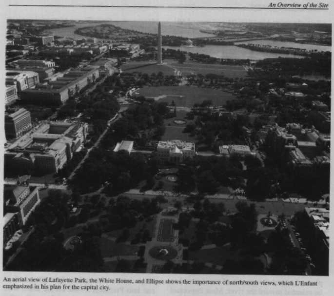
An Overview of the Site

property dominated its development until the mid-19th century.

Andrew Jackson Downing, 1851

Downing's l851 plan for President's Park is the first detailed development plan. While this plan respected L'Enfant's initial concepts, it also reflected Victorian approaches to design. The design for Lafayette Park continued to reflect a space more related to the surrounding neighborhood than to the White House, with a central elliptical walkway bisected on the north and south by two additional walkways curving in towards the center of the park In the center of the park a pedestal was installed as a base for an equestrian statue of Andrew Jackson dedicated in 1853.

Downing designed the Ellipse as a broad, flat acreage bordered by a circular drive with a walk bordered by trees. The remainder of the property was evidently to be heavily planted with small wooded areas and traversed by winding walkways and paths. Downing envisioned the Ellipse as both a military parade ground and as a place for public celebrations and recreation.

It is unclear how much of the plan was initiated before Downing's death in 1852, however, portions of the Lafayette Park plan were implemented. The L'Enfant and Downing plans remained the general standard for property development until the Olmsted plan of the 1930s.

Senate Park Commission Plan (McMillan Plan), 1901

The 1901 Senate Park Commission plan (the McMillan plan) used L'Enfant's original design as a base and refined some concepts concerning the Mall and President's Park. As promoters of the City Beautiful movement of the late 19th and early 20th centuries, the commission members (consisting of Daniel H. Burnham, Frederick Law Olmsted Jr., Charles F. McKim, and Augustus Saint-Gaudens) traveled to Europe to survey works that might have influenced L'Enfant. The Treasury Building, the Executive Office Building, Downing's "Parade," and the general plan for Lafayette Park were left intact, and East and West Executive Avenues remained. However, this plan proposed that the Ellipse become a circle, and that the dogleg drives at the corners be removed; these items were never initiated. Tree plantings were designated along the east and west borders of the Ellipse, leaving the bulk of the southern property open. The plan had little specific effect on President's Park except in a general sense, acknowledging the property as an important element in the overall fabric of the Monumental Core.

McKim, Mead and White, 1902

A major renovation of the White House in 1902 changed the formal business and reception orientation of the building and grounds. The East and West Wings became primary entrance and exit points, while the north and south porticoes were used more for ceremonial functions. A drive was retained from the north to the West Wing, servicing the "temporary" office established by President Theodore Roosevelt in 1902.

Olmsted Brothers, 1935

The plan formulated by Frederick Law Olmsted Jr. and his associates reemphasized the importance of the L'Enfant vistas to the south and north and called for the removal and addition of plantings to complement this concept. The Grant administration's fiddle shaped drive immediately south of the White House was replaced by a circular roadway, with a sunken south drive running from east to west. While Olmsted concentrated on "matters

--133--


THE AFFECTED ENVIRONMENT

of appearance," seclusion, and privacy for the first family, he also addressed parking, service and delivery areas, communications, circulation, and formal gardens. Olmsted particularly wanted to see the formal entrance to the White House reestablished at the north portico instead of the East and West Wings as designed by McKim, Meade and White in 1902. Olmsted's 1935 plan, based on previous work by Downing as well as L'Enfant, has served as the guide for all landscape work within the White House fence to the present day.

The Olmsted brothers discouraged the use of East and West Executive Avenues as major traffic routes. They did suggest E Street as an east/west traffic route (later reinforced by the use of State Place). Maps as early as 1932 show plans for extending E Street through the property, and by 1936-40 the roadway was in operation. When E Street was connected to freeway systems on the west in the 1960s, a major arterial thoroughfare bisected President's Park.

National Park Service, ca. 1935

Lafayette Park (renamed from Lafayette Square in 1933) was substantially reworked by the National Park Service in the 1930s. Many of the Downing-inspired serpentine secondary walks were removed and new walks installed. A new walk design, based on the original Downing scheme, was installed. Plant material was reworked, with thoughts to opening the vista to the north. The two bronze urns placed in the park in 1872 were relocated to the eastern and western edges of the park.

Truman Renovation, 1952

The grounds of the White House were changed into a construction yard between 1949 and l952 to accommodate the extensive renovation of the mansion. As a result, the grounds required complete relandscaping, accomplished for the most part by the National Park Service. Many individual elements were replaced, removed, or relocated; however, the Olmsted plan of 1935 served as the guiding principle in restoring the grounds and the major roadways and configurations.

John Carl Warnecke Associates, 1962-69

As previously mentioned, this work focused on Lafayette Park. The 1930s walk design, based on the Downing plan, was retained, with the walks paved in brick. Two fountains were built east and west of the Jackson statue in place of the bronze urns (dating from 1872). The urns were moved to the park's central entrance on the south (where they are today).

-134-

CULTURAL AND NATURAL RESOURCES

Cultural Resources

The cultural resources associated with President's Park and Lafayette Park include the cultural landscape, archeological sites, historic districts, buildings, monuments, structures, landscapes, roadways, and plantings.

Cultural Landscape

The character of President's Park is complex, consisting of both built and natural components that have developed over 200 years. Its present ambience is created by combination of individual elements - historic districts and buildings, monuments, structures, landscapes, roadways, and plantings-that combine to produce a special feeling and sense of place. However, the overall effect has been diminished over the years by the inconsistent use of site details and landscape treatments.

The White House and President's Park

President's Park retains its original spatial arrangements and purpose as the setting for the official home and office of the president and as a place of assembly for the nation at large. The site's architectural character conveys the importance and dignity of the presidency, while the landscape fulfills a similar role, reflecting the classical principle of decorum -the selection of building styles and sites to evoke an appropriate public message of power and respect (Calloway and Cromley 1991). As the site of the home and office of the president, this is a traditional cultural landscape and is ceremonial by design. The landscape also serves to frame L'Enfant's ceremonial vistas and to provide an appropriate setting for the executive buildings.

President's Park reflects the landscape design tradition of the early republic and a combination of French and English traditions. The Ellipse, the south lawn of the White House, and Lafayette Park act as a "sequence of open spaces," framing the White House and enhancing its grand vistas and axial relationships as set out by L'Enfant in his plan for the city. President's Park also evokes the 19th century English Romantic period, where nature no longer was seen as something to be conquered but rather as integral to the human environment -- "a friendly and equal partner which could provide inexhaustible interest, refreshment and moral uplift" (Jellicoe 1987). This philosophy can be seen in curvilinear path and roadway systems, the use of various plant materials, and the picturesque and irregular massing of trees and shrubs.

The 1850s design for the Ellipse by Andrew Jackson Downing is based on this English Romantic tradition. Downing designed these large open spaces as gathering places and a point of assembly for official and unofficial uses in the center of the city - a function they continue to serve. The City Beautiful movement at the turn of the 19th century in the United States also affected President's Park by introducing a number of monuments and statuary into the landscape.

To this day, the landscape components of President's Park remain generally informal and romantic. However, the overall spatial landscape arrangement in relation to other public open spaces is formal, based on a series of classical circular and elliptical forms from north to south, widening in size and scale as

-135-


the landscape opens to what was the original river vista, now occupied by monuments.

Even though President's Park is comprised of three separate parts (Lafayette Park? the White House grounds, and the Ellipse), they are all aesthetically linked. Within these major divisions are separate park areas with distinctive site characters, such as Sherman Park, the First and Second Division Monuments, and the Boy Scout Memorial. It important that there be continuity among all of these discrete elements so they contribute to the overall park environment.

The Urban Setting

How one enters and moves through President's Park affects how one perceives this area. When entering the site from adjacent neighborhoods to the west, north, and east, one is aware of passing from densely developed urban streetscapes into an open area with lawns, trees, and statues before attention is drawn to the White House and its grounds. When entering the site from the south, one is aware of a gradual transition from large ceremonial and memorial spaces within the Monumental Core to President's Park and then to an urban setting. Within President's Park, one can sense the symbolism of the urban design and the reciprocal linkages to both the Monumental Core and downtown Washington.

While L'Enfant's intent - that the home of the president be the focus of broad vistas and grand approaches - was never fully realized, his conception of how President's Park relates to the city plan is still valid. Today, the basic urban design form evident in and adjacent to President's Park must be considered as a composite of landscape and architectural features, streetscapes and buildings, site specific details and long-range views. These basic forms are articulated and tied together by major public walkways and thoroughfares. The complementary relationship between the home of the president and the city is symbolized by views toward the White House that are just as dramatic as those from the mansion's north door or the south portico. Over the past 200 years surrounding urban development has become dominant and out of proportion to the scale of the White House as a building, but the distinctive setting of the executive mansion within President's Park still emphasizes its importance.

Archeological Resources

Even though the White House and its grounds are exempted under section 107 of the National Historic Preservation Act of 1966, several formal reports have been prepared over the years (Knox 1969; Humphrey and Chambers 1977, 1984; Marshall 1975; Young 1977; Sinnott 1979, NPS, Pousson 1 98 1; Moore and Chase 1992; and NPS, Pousson and Hoepfner 1995). Except for the 1995 overview by Pousson and Hoeptner, all have been specifically focused, and none has made conclusive findings.

Prehistorically, the site overlooked an estuarine environment, making it a prime location for habitation. Evidence of such occupation consists of prehistoric stone points, along with other flakes and artifacts, discovered in 1975 in the vicinity of the outdoor swimming pool and a stone biface and point discovered on the Ellipse in 1976.

Historic archeological information is more conclusive. The farmlands and settlements preceding the establishment of the federal city are well documented. The Pearce (later the Burnes) farm, whose lands are now a part of the President's Park, included an apple orchard and family cemetery in the vicinity of present-day Lafayette Park. The pre-Revolutionary War town of Hamburg was platted to the southwest of the property.

--136--


Cultural and Natural Resources

After the burning of the White House in 18l4, some of the rubble from the interior of the building was apparently dumped on the grounds, and some material was uncovered in 1975 in conjunction with the swimming pool excavation. Material was also likely left from encampments during the Civil War and from various construction projects, including the building and removal of several ancillary structures (such as stables, vaults, cisterns, greenhouses, and privies). The southernmost grounds of the White House and the Ellipse are mainly fill; the Ellipse operated as a public dump for many years, as officials attempted to raise the terrain's grade. During nearly every major war some sort of temporary installation has been built on or adjacent to the property. Other remains have also been discovered, such as the 19th century foundations that were uncovered during the construction of the visitor entrance building on East Executive Avenue in the 1980s or the items uncovered during the installation of safety bollards south of the White House in 1990.

Historic Structures and Districts

President's Park includes five historic districts and 69 separate elements that are listed on the National Register of Historic Places, that are designated as national historic landmarks, or that are recognized by the District of Columbia. The various designations are listed in table 3; specific historic buildings are described in appendix C, and districts are shown on the Historic Districts map.

In addition, memorials, structures and general plans within President's Park are listed or may be individually eligible for listing on the National Register of Historic Places or as national historic landmarks because of their associations with individual designers, planners, and artists (see the Memorials / Monuments map).

The historic buildings within President's Park are administered under a variety of jurisdictions - the Executive Office of the President, the Executive Residence at the White House, the General Services Administration, the U.S. Treasury Department, and the National Park Service. Each entity has separate historic preservation and curation programs for its buildings and collections.

Historic structures within an urban setting are subject to various effects, ranging from exhaust fumes and airborne pollutants to traffic vibrations. Traffic vibrations are a potential problem along H Street, particularly to those l9th century structures with brick or stone rubble foundations. It is not known if monumental structures such as Treasury Building and the Old Executive Office Building are affected by traffic on 15th and 17th Streets; due to the varied foundation systems at Treasury, such disturbance is possible. Heavy truck traffic in the courtyards of the Old Executive Office Building might also be having an undetermined effect.

White House Collection
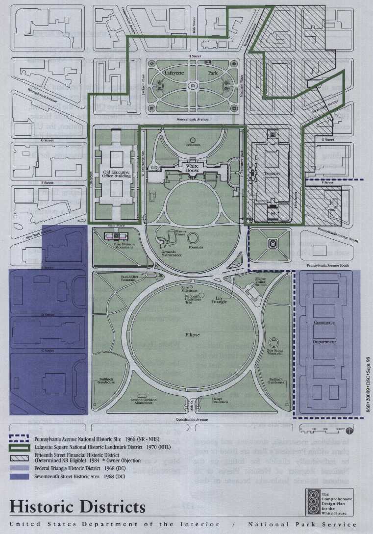
The White House collection consists of thousands of separate items, including both decorative and fine art objects. Examples include household items such as furniture, specially loomed carpets and drapes, and china, crystal, and flatware service (including items from early administrations). Also included are one of a kind art objects and canvases by Jean Antoine Houdon, George Caleb gingham, John Singer Sargent, James McNeil Whistler, Mary Cassatt, Claude Monet, and other nationally and internationally known artists.

-137-


Historic Districts

--138--


Cultural and Natural Resources

Table 3: Potentially Affected Historic Structures, Sites, and Districts
In and Near President's Park

Historic Structure, Site, or District

Designation
The White House and Presdent's Park

Lafayette Park

Lafayette Square National Historic Landmark District

Von Steuben Statue
Rochambeau Statue
Kosciuszko Statue
Lafayette Statue
Sherman Statue

National Register of Historic Places-1970; National Historic Landmark-1970; District of Columbia Historic District-1973
National Register of Historic Places-1970, 1977
National Register of Historic Places -- 1970, 1977
National Register of Historic Places-1970, 1977
National Register of Historic Places-1978, 1980
White House Complex
White House
Treasury Building
Old Executive Office Building

National Historic Landmark-1960
National Historic Landmark-1971
President's Park South
First Division Monument
Butt-Millet Fountain
Zero Milestone
National Christmas Tree
District Patentees Memorial
Boy Scout Memorial
Bulfinch Gatehouses
Second Division Monument
Haupt Fountains
National Register of Historic Places-1980
National Register of Historic Places-1978
National Register of Historic Places-1973, 1978
National Register of Historic Places-1978
Structures and Districts Adjacent to the White House and President's Park
Lafayette Square National Historic Landmark District
Decatur House
St. John's Church
Ashburton House
Blair House
U.S. Chamber of Commerce Building
Treasury Annex
Renwick Gallery

See above.
National Historic Landmark-1960
National Historic Landmark-1973
National Register of Historic Places-1970, 1992

National Historic Landmark-1971

Seventeenth Street Historic Area
Corcoran Gallery of Art
Organization of American States Building (Pan-
American Union)
The American Red Cross National Headquarters
Daughters of the American Revolution Memorial
Continental Hall and Constitution Hall

District of Columbia Historic District-1968
National Register of Historic Places-1971
National Register of Historic Places-1969

National Historic Landmark-1985
National Historic Landmark-1972 and 1985

Pennsylvania Avenue National Historic Site National Register of Historic Places-1966; National Historic Site -- 1966; District Of Columbia -- 1973
Fifteenth Street Financial Historic District District of Columbia-1981
Eliaible for National Resister of Historic Biases-1984
Federal Triangle Historic District District of Columbia-1968

NOTE: Many elements have multiple listings; for further information consult the President's Park, Cultural Landscape Report" (EDAW 1995)

-139 -


-140-

Cultural and Natural Resources

Little storage exists on the site for pieces from the collection, and there are no adequate facilities for the immediate securing of dam-aged items awaiting shipment to conservators. Because most storage is offsite, items must be repeatedly transported to and from the White House as needed, resulting in a higher potential for damage during transport and handling.

Commemorative Plantings

The 41 commemorative trees planted by presidents and first ladies on the White House grounds date from as early as 1829-37, when President Jackson planted southern magnolias near the south portico. An Americana elfin that dated from the earlier presidency of John Quincy Adams has been reestablished with a graft of the original tree. A commemorative shrub hedge of English and American boxwood was planted by President Truman in 1952.

Natural Resources

Geology and Topography

Washington, D.C., is a region of dissimilar geologic features. The District of Columbia spans the fall line separating the Piedmont physiographic province on the northwest from the Coastal Plain province on the southeast. The fall line roughly follows Rock Creek Park, traversing northwestern Washington in a north-south direction. The Piedmont province is composed of generally hard igneous and metamorphic rock originating from sedimentary and older igneous rock. The Coastal Plain is underlain by younger, poorly consolidated sediments of silt, sand, clay, and gravel (SCS 1976; USGS 1964). President's Park is in the Coastal Plain, near the fall line.

Past investigations within and adjacent to President's Park indicate bedrock dips in a
southeasterly direction across the study area. The elevation of sound bedrock varies from -30' to -70', with an average elevation of -40' to -50' (or approximately 75' below the ground surface, depending on ground elevation). Bedrock high points could be encountered in some areas with bedrock elevations between O and -30' (Schnabel Engineering Associates 1994).

President's Park occupies parts of two terraces, which in turn are part of a series of terraces that increase in elevation and age farther from the Potomac River. Lafayette Park and the north lawn of the White House occupy a higher terrace, while the rest of the site (which has been modified by fill) occupies eroded remnants of one or two more recent terraces. The higher terrace, which was subsequently named the F Street ridge, extended more or less directly east and west from the present-day site. South from the F Street ridge, the ground sloped into a low, wet area of an eroded terrace. At the south end of the site, the ground rose again to a higher elevation terrace, a remnant of which evidently formed a low bluff. Beyond this bluff was the tidal marsh at the confluence of the shallow Tiber Creek estuary with the Potomac.

The President's Park area reflects the pressures of urban density and growth. The original landform was manipulated to create an appropriate setting for the executive branch, and examples of this manipulation may be seen throughout the area.

The site was excavated and leveled to allow the construction of surrounding streets and for landscaping; as a result, the elevation of Lafayette Park is perhaps 3' lower than it was in 1797 (NPS 1995b, 26). Another example is the north lawn of the White House, which was originally part of the F Street ridge. Most regrading of this area occurred on the west side, and cut material was used for leveling on the east side of the north lawn.

-141-

Commemorative Trees and Shrubs

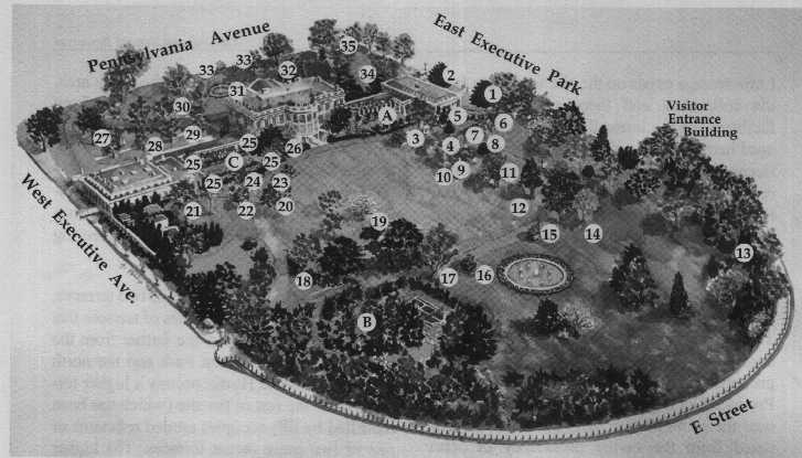
1. Southern Magnolia - Franklin 13. Roosevelt (1942)
2. Southern Magnolia - Warren G. Harding (1922, replanted 1947)
3. Willow Oak - Ronald Reagan (1988)
4. Small-leaved Linden - George Bush & Queen Elizabeth II (1991)
5. White Pine - Gerald Ford (1977)
6. Fnsfern Redbud - George Bush (1990)
7. Northern Red Oak - Dwight D. Eisenhower (1959)
8. Patmore Ash - George Bush (1989)
9. White Dogwood - Bill & Hillary Clinton (1995)
10. White Dogwood - Bill & Hillary Clinton (1996)
11. Purple Beech - George Bush (1991)
12. Amtricatt Elm - John Q. Adams (original 1826, Barbara Bush 1991)
13. White Oak - Herbert Hoover (1935)
14. Willow Oak - Bill & Hillary Clinton (1993)
15. Japanese Maple - Rosalyn Carter (1978)
16. Japanese Maple - Frances Folsom Cleveland (1893)
17. American Elm - Bill & Hillary Clinton (1993)
18. White Dogwood (3) - Hillary Rodham Clinton (1994)
19. Cedar of Lebanon - Jimmy Carter (1978)
20. White Oak Herbert Hoover (1931)
21. Pin Oak - Dwight D. Eisenhower (1958)
22. Small-leaved Linden - Bill Clinton (1993)
23. Small-leaved Linden - Franklin D. Roosevelt (1937)
24. Willow Oak - Lyndon B. Johnson (1964)
25. Saucer Magnolia (4) - John F. Kennedy (1962)
26. Southern Magnolia (2) - Andrew Jackson (1830)
27. Sugar Maple - Ronald Reagan (1984)
28. Fern Leaf Beech - Patricia Nixon (1972)
29. Fern Leaf Beech - Lady Bird Johnson (1968)
30. American Elm - Betty Ford (1975)
31. English and American Boxwood (shrub) - Harry S. Truman (1952)
32. Red Maple - Jimmy Carter (1977)
33. White Saucer Magnolia (2) - Nancy Reagan (1982)
34. White Oak - Franklin D. Roosevelt (1935)
35. Scarlet Oak - Benjamin Flarricon (1889)

Gardens

A. Jacqueline Kennedy Garden (1965)
B. Children's Garden - Lyndon B. Johnson (1969)
C. Rose Garden

White House Grounds:
Commemorative Plantings & Gardens

--142--

Cultural and Natural Resources

The area closest to the White House on the south side reflects some aspects of the original landform (NPS 1995b, 59). The grade is several feet lower than that of the north lawn, taking advantage of the natural terracing of the south slope. However, the uniform slope of the south lawn and the Jefferson Mounds are the result of grading and reshaping. The lower area of the south lawn (south of the existing eastwest drive at the lower end of the south lawn) originally sloped more steeply toward a marshy area in the northern part of the present Ellipse. Filling in this area began as early as the 1800s.

The Ellipse consists of artificial fill underlain by alluvium, river terrace deposits, and upland gravel and sand deposited by an ancestral Potomac River. Beneath these terraces are the preconsolidated clays, silts, and sand of the Potomac group (SCS 1976).

Soils

Two soil mapping units have been identified within the study area. The Beltsville-Urban land complex (0% to g% slopes) underlies Lafayette Park and bisects the north lawn of the White House diagonally from northeast to southwest. Udorthents underlie the southeast portion of the north lawn, the White House, the south grounds, and the Ellipse (SCS 1976).

- Soils formed in the parent material of a silty mantle most likely deposited by wind. These moderately well-drained, nearly level to gently sloping soils occupy high elevations of the Coastal Plain.

Approximately 20% of the complex is comprised of relatively undisturbed Beltsville soils. Another 20% has been disturbed by urbanization and covered with as much as 20" of fill. Urban land comprises approximately 40% of the complex and underlies areas covered by asphalt, concrete, buildings, and other impervious surfaces. The remaining 20% of the complex includes Bourne fine sandy loam, Chillum silt loam, Matapeake silt loam, Sassafras sandy loam, and Sassafras-urban land complex (SCS 1976).

Although general properties are available for this complex, an onsite investigation is needed to determine the soil potentials and limitations for any proposed use. Generally, permeability and internal drainage of these soils are slow. Hazard of erosion is moderate to severe; runoff is medium to rapid. Available water capacity is moderate in relatively undisturbed areas, but is low to very low in highly urbanized areas.

Udorthents. Udorthents formed in parent material that has been deposited or disturbed by man as a result of cuts and excavations. Udorthents can be found on poorly drained to somewhat excessively drained soils on floodplains, terraces, and uplands. In many areas this mapping unit is covered by structures, asphalt, concrete, and other impervious surfaces, and material was brought in to facilitate the construction of buildings, roads, railroads, recreation areas, and other development (SCS 1976).

In the southern portions of President's Park about 80% of the mapping unit consists of sandy, gravelly, clayey, silty, and micaceous soil material. The remainder of the mapping unit is organic and inorganic waste from human activity, including bricks' trash' wire, metal' boards, cinders, industrial wastes, incinerator ash, and pieces of concrete and stones. Because of the diverse composition of this unit, permeability, available water capacity, run-off, and internal drainage are quite variable (SCS 1976).

-143-

The Affected Environment

Uncovered and nearly level areas of Udorthents containing few coarse fragments are generally high in fertility and available water capacity. As a result, potential is good for lawns, trees, ornamental shrubs, and recreation areas. Such uses are found in the Mall and in the grounds of the Capitol and the White House (SCS 1976).

Fill

The depth of fill material within the study area ranges from 2.5' to 20' (see table 41. The Ellipse consists entirely of late 19th century fill-clay, silt, and sand, with occasional bricks, cinders, coal, shells, and metal debris. Geotechnical sampling recorded the thickest fills near the northern part of the Ellipse and E Street, with shallower fills towards the southern Ellipse (Dames and Moore 1986; Schnabel Engineering Associates 1991, 1994). A comparison of an interpolated contour map of the site's original topography with an existing conditions map indicates that fills in the northern part of the Ellipse are 18'-20' feet deep overlying natural soil. Toward the southern end, in the area of present-day Constitution Avenue and the former creekside bluff, the fills may be no more than 3'-7' deep. Much of this fill was placed gradually within the Ellipse area in the 1870s, using soil as well as refuse and construction debris dumped by citizens. By 1880 the Ellipse was at grade with the surrounding area (EDAW 1995).

TABLE 4: FILL AND UNDERLAYERS IN PRESIDENT'S PARK
Location Layer Thickness of Layer
15th and I Street Fill
Stiff to hard silty clay and clayey silt
Dense to very dense sandy clay and gravel, sand and gravel
5-10'
35'
30'-35'
Pennsylvania Ave. and Madison Pl. Fill
Stiff to very stiff silty clay
Medium dense to very dense sand
and gravel
4'-8'
13'-16'
15'-19'
South of the Old Executive Office Building Fill
Medium dense to very dense silty sand, and fine to coarse sand and gravel
11'
54'-59'

E Street (14th St. to 17th St.)

15th and E St.

Fill
Soft clay and loose sand
very stiff clays and medium dense to very dense sand and gravel with clay
Topsoil

8'-20'
3'-4'
30'

8'

Northeastern Ellipse area Fill
Soft to loose sandy clay and silty sand
Medium dense sifty sand and stiff to very stiff clay

19'
3'-4'

10'

Southern Ellipse area Fill
Medium stiff to stiff silty clay with areas of granular material
Dense to very dense sand and gravel
Stiff to very stiff silty clay
2.5'-14'
15'-30'
3'-7'
?

SOURCE: Schnabel Engineering Associates 1991.1994.

-144-

Cultural and Natural Resources

Beneath the fill are layers of extremely variable materials, with texture ranging from clay to sand in the test borings. Most materials directly beneath the fill are silty clay and some sandy clay. This material ranges from loose to very stiff in consistency. A layer of dense to very dense variable textures of sand and gravel underlie the clay.

Overburden

The thickness and composition of overburden is important in determining the suitability of an area for development. Overburden is all the surface earth material overlying hard bedrock. Overburden includes soil, disturbed ground and artificial fill, alluvial and terrace deposits, colluvium, upland gravel, Coastal Plain strata, and saprolite on crystalline bedrock (SCS 1976).

Areas with thin overburden are more conducive to development that needs strong bedrock for structural support, such as utility and pipe-line alignments requiring deep burial. Over-burden in the study area ranges from 50' to 100' thick in the major portion of the area. On the eastern edge of the study area over-burden ranges from 100' to 150' thick (SCS 1 976).

Soil Compaction

Soils throughout President's Park, particularly on the Ellipse, have been subjected to major human impact, both from daily uses such as heavy foot traffic and from special events that involve the long-term use of heavy equipment and infrastructure and a large number of participants. As a result of these activities, pore space between soil particles has been reduced and soils have become compacted.

Soil compaction is a major contributing factor in the premature death of trees and other vegetation in President's Park and the Mall. Generally, soil pore space should be about 50% to allow diffusion of oxygen, water, and minerals. Water or oxygen may be available in soils, but unable to move through the soil because of compaction. As a result, trees can be suffocated by soils that do not breath or drain (MacDonald 1994).

Compacted soils also physically restrict root growth. Soil in test pits on the National Mall have been found to be "as dense as concrete." The roots of trees planted in this soil are unable to grow beyond the original planting hole, thus constricting growth. Soils in President's Park are similar (MacDonald 1994).

Climate

Washington, D.C., is about 50 miles west of Chesapeake Bay, adjacent to the Potomac and Anacostia Rivers. The summers are warm and humid and the winters cold, but not severe. Periods of pleasant weather often occur in the spring and fall. From June through August daytime temperatures average in the upper 80s; the hottest month is July, and the highest recorded temperature for July is 104°F. From December through February daytime temperatures are in the low 40s to 50s; the coldest month is January, and the coldest recorded temperature for this month is -5°F.

Precipitation is uniformly distributed through-out the year, with a normal annual rainfall of 39". Thunderstorms can occur at any time but are most frequent during the late spring and summer; August is the wettest month of the year. Typically, thunderstorms are accompanied by gusty winds, but they are not usually severe. Tornadoes occur infrequently, but severe springtime hailstorms do occur. Tropical storms with heavy rains, high winds, and

-145-

The Affected Environment

flooding also occur in the area. Average snowfall during the normal winter season (November to March) is 18". While snowfall of 10" or more in 24 hours is unusual, notable falls of more than 25 " have occurred.

Air Quality

As required by the Clean Air Act, national ambient air quality standards have been established for carbon monoxide, nitrogen oxides' ozone, particulate matter, sulfur dioxide, and lead. Within the study area ambient concentrations of carbon monoxide and ozone result primarily from motor vehicle activity; emissions of nitrogen oxides and particulate matter result from mobile and stationary sources; and emissions of sulfur oxides and lead are associated mainly with various stationary sources of emissions. Even though there are no air quality monitoring stations within or adjacent to the study area (the closest monitoring station is at 21st and L Streets), pollutants most likely to be of concern near President's Park are those associated with motorized vehicles carbon monoxide, ozone, and nitrogen oxides.

Areas not in compliance with the national standards are termed nonattainrnent areas by the U.S. Environmental Protection Agency. The Washington, D.C. / Maryland / Virginia Metropolitan Statistical Area is classified as a serious nonattainment area for ozone (formed from volatile organic compounds and nitrogen oxides in the presence of sunlight); the federal health standard for ozone was exceeded every year except one from 1973 to 1993. The Metropolitan Washington Air Quality Council (an organization consisting of the Metropolitan Washington Council of Governments plus St. Mary's, Charles' and Stafford Counties) has prepared plans calling for a 15% reduction in volatile organic compound emissions. The state implementation plans for improving air quality identify control measures for reducing volatile organic compounds and nitrogen oxides to comply with the national ambient air quality standards by 1999. Some of the control measures identified in the state plans include federally mandated measures such as "high-tech" inspection/ maintenance, stage II vapor recovery nozzles? and stringent motor emissions standards.

In 1996 the metropolitan Washington region was redesignated as an attainment area for carbon monoxide (the area had been a moderate nonattainment area in 1990).

Water Resources

Surface Water

Water Quantity and Use. Washington, D.C., lies within the Potomac River basin. The Potomac and its main tributary, the Anacostia River, are the primary streams draining the area. The rivers form an important estuary and comprise the second largest tributary water-shed emptying into Chesapeake Bay, supplying approximately one-fifth of the annual total freshwater input to the bay (DC 1992c).

The study area is within the Potomac River watershed, less than 3 miles by air from its confluence with the Anacostia. The Potomac River provides about 75% of the municipal water supply for drinking and domestic uses in the Washington metropolitan area. The Army Corps of Engineers is responsible for supplying water to the District through its Washington Aqueduct agency. Other uses include recreational, industrial, and commercial fishing. The river also absorbs effluent discharged from a number of wastewater systems (MWCOG 1993).

No perennial surface waters occur within the study area. A branch of Tiber Creek once flowed above ground from springs on the

-146-

Cultural and Natural Resources

Soldier's Home grounds and emptied into the Potomac at l7th Street and Constitution Avenue. In the 1870s the stream was placed underground as a trunk sewerline of the flush system for the Washington Canal (O'Connor 1991). The majority of the combined storm-water and sanitary sewer lines in the District were installed during this period.

Groundwater

Quantity. Current information about ground-water is limited. However, the abundance of groundwater becomes obvious during under-ground construction, when extensive pumping is often needed The installation of permanent sump pumps is a frequent practice, especially in areas of river terrace deposits (DC l992c).

A geotechnical review of subsurface conditions indicates that groundwater levels vary significantly across the study area (Schnabel Engineering Associates 1994; Dames and Moore 1986). Generally, groundwater levels are deeper in the northern sections of the study area (Lafayette Park) and shallower in the southern sections of the Ellipse. Boring data show the greatest depth below surface one block north of Lafayette Park near 15th and I Streets, where borings measured groundwater levels at 40' to 50' below surface elevations. Higher groundwater levels, approximately 8' to 15' below ground surface, were found under E Street between the northeastern portion of the Ellipse and Executive Avenue (Schnabel Engineering Associates 1994). Across the southern portion of the Ellipse, groundwater levels range from 4' to 16' below ground surface (Dames and Moore 1986).

Groundwater levels fluctuate as a result of variations in environmental conditions, surface drainage, and other factors (Schnabel Engineering Associates 1991). Fluctuations
signify variable interbedded soils in the study area and possibly indicate old drainage pat-terns connected with the historic canal along Constitution Avenue. Seasonal changes in groundwater levels tend to vary as much as 5' in the southern area of the Ellipse (Dames and Moore 1986).

Quality. Information on the quality of groundwater in the District is very limited and mostly site specific. Data primarily relate to remedial actions, such as results of site investigations of leaking underground storage tanks (DC 1992c). A cooperative effort has been implemented to gather hydrogeologic information. In 1989 a groundwater protection program was initiated, including a ground-water assessment and determination of quality. Monitoring wells have been installed to collect and analyze data (DC 1992c). Flooding or sewer overflows occur sometimes near Constitution Avenue and 14th, 15th, and 17th Streets during periods of above-average precipitation (pers. comm., Eb Strealy, Water and Sewer Utility Administration, 1996).

Floodplains

President's Park is outside the limits of the 100-year and 500-year floodplains. It is within an expansive area designated as zone C on the flood insurance rate map (Washington, D.C, Community-Panel Number 110001 0020 B. effective date: November 15, 1985). Areas of minimal flooding may occur within this zone.

Floods on the Potomac River are caused by both tidal flooding from Chesapeake Bay and upstream flood flows. Record flood flows combined with high tide elevations occurred at about the same magnitude (approximately 484,000 cfs) in 1889 and 1936. Existing flood controls in Washington were put in place as a result of the 1936 flood.

-147-

Comprehensive Design Plan Continued